Right from the very start of the project, the help of the public has been essential to our work. People have sent us individual names, lists of names, old and modern documents and every kind of map for us to upload their names to the List. We're very grateful for all the help, and for all of the names that we've been sent. Unfortunately, one thing has always hindered the work, and that's the need to geo-locate the names. We need to know, at least roughly, where each name refers to, and since we've only got one member of staff, it's impossible for us to have the degree of precise local knowledge necessary to do this all across the country. Similarly, the people who send us names know where they are, but they may not be sufficiently familiar with grid references to send us a precise enough location. We've solved this problem.

We've been doing a bit of technical development work on the website recently, and all of the changes are now live. As you can see in the above picture, we've added a new button on the left hand side of the screen. This will allow people to find the co-ordinates of anywhere in Wales. All you need to do is click on the button outlined in red in the picture. That will change the cursor. If you then click on the map, a popup will appear with the co-ordinates.

If you send us the name, co-ordinates and the date of the name (that is, as far as you know, the year since which that name has been used), we'll add them to the List as soon as possible. When you're finished searching for co-ordinates, click on the button on the left again, and the cursor will return to normal. We really hope that this will be a clear and easy way for the public to take part in the project, and to enable us to collect more names which don't exist on maps or in documents, but survive in the memories of the people.
The List of Historic Place Names was established to record and protect Wales' place names, and to prevent them being replaced by new names. We're all aware of the more famous examples of this, like Faerdref Fach being called Happy Donkey Hill because of the new donkey sanctuary, or tourists calling Llyn Bochlwyd 'Lake Australia'. It's our duty to defend Wales' place names, and ensure that they are used for generations to come. In order to help us achieve that goal, Cylch yr Iaith have sent us a list of names which are under threat of anglicisation, and they've now been added to the List. Once a name is in the List it will be remembered, even if it's disappeared from the wall plaque, so it's vital that every place name in Wales finds its way to the List, in order to be safeguarded.
You can see the names here.
It's important to remember that history is an ongoing process, and that things which are modern now will be historic one day. That's why we collect contemporary names, as well as historic forms, so that nothing is lost. A good example of this is the map that we came across in Felinwynt, Ceredigion, which shows the names of all of the houses in the area, some historic, some modern. We've added the names to the List, and we want to do the same in other areas of the country, so if your Community Council or your village has a map of local place names, please take a photo and send it in to us.
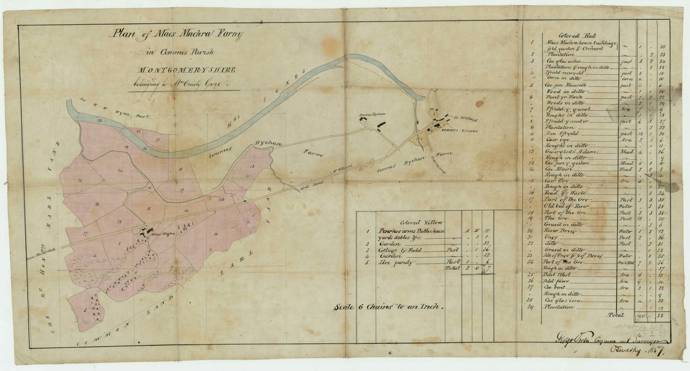
The List of Historic Place Names has reached an important new milestone recently - we now have more than 700,000 names. Recently we've been adding names from two sources; the first is A Study of Breconshire Place Names by Richard Morgan and Peter Powell, and the other is two maps of Maes Machreth, a farm near Glantwymyn in Montgomeryshire.
A Study of Breconshire Place Names was published in 1999, and contains historic forms of 340 Welsh language names from the county, as well as a description of their etymology. We're still working on uploading all the forms from the book, but so far we've got 555 of them in the List. They add to our understanding of the development of the names of Breconshire's towns, villages, mountains and rivers, and there's a few house names in the mix as well.
The family at Maes Machreth were kind enough to give us an old map of the farm, dating from 1857, which shows the names of the fields. We're also lucky that the field names were recorded by the Tithe in 1841, so we can show that there wasn't much change in the decade and a half between the two. However, the family have also given us a modern map, showing the names which are currently in use, and there's been a fair bit of change in the intervening 180 years. Cae'r lloi is now Barnfield, Gwerglodd Adam has become Cae Maen and some names have changed location, such as Cae ogof, which has moved across the road and replaces the name Cae pen y geulan.
Continuing with field names, we're currently in discussions with Rural Payments to collect current field names, so we hope, in the near future, to be able to see how Wales field names have changed since the Tithe, and perhaps even to fill in some of the gaps that weren't recorded by the Tithe Commissioners.
As you'd expect for a website and project on Wales' place names, the Welsh language is very important to us. After all, the vast majority of our place names come from Welsh! There are thousands of people learning Welsh as adults at the moment, from all across Wales and beyond, and we believe that we have a duty to support them in their learning. That's one of the main reasons that we added sound files to the glossary for example, as you can see here.
We've also set out to preach the importance of Welsh place names, and the work of the List, directly to learners, through giving talks to Welsh for Adults classes. We contacted the Canolfan Dysgu Cymraeg Cenedlaethol, the national centre for Welsh for adults, and offered talks for classes at Uwch or Gloywi level.
We've spoken to four classes already this year, with more on the way, but as per usual with us, we want to reach as many people as possible, so if you're a Welsh teacher, or a learner, contact us through the contact form. We can offer talks either face to face or on Zoom, so that they're suitable for every class.
The talks are tailored to focus on place names that are (reasonably) local to the learners, so every talk is different. Give it a try!
As well as the talks to classes, James has also begun a monthly column on Lingo360, the online magazine for learners. Each article is provided with a glossary, so that you can follow the article irrespective of your level of Welsh. Two articles have been published so far; the first is a general introduction to the work of the project, which you can find here. The second is a discussion of the name Llanbrynmair, a village in Powys, and how it's moved down the valley over the past century, which can be found here.
Second in our series on the most recent sources we have been adding to the List is the Multilayer Map project, or the Deep Mapping Project.
Deep Mapping Estate Archives is an Arts and Humanities Research (AHRC) funded collaborative project across Welsh universities, archives, and heritage institutions. The project has digitally mapped historical records to the real-world locations they relate to, which allows for in-depth analysis of landscape continuity and change.
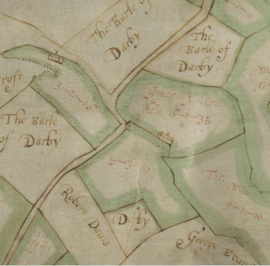
This pilot project has been focused on a small area of North East Wales consisting of three parishes in Denbighshire; Llanarmon yn Iâl, Llanferres and Llandegla and three adjacent parishes in Flintshire; Treuddyn, Nercwys and Mold (as far as the river Alyn). The project has brought together a wide range of large-scale historical maps to create a free, publicly accessible web map:
- 1869-1874 | Ordnance Survey County Series Mapping (25.344 inches to 1 statue mile or 1:2,500)
- 1871 | Ordnance Survey Town Plan (126.72 inches to 1 statue mile or 1:500)
- 1837-1848 | Tithe Survey Mapping (Various scales)
- 1800-1830 | Enclosure Mapping (Various scales)
- 1620-1858 | Estate Mapping (Various scales)
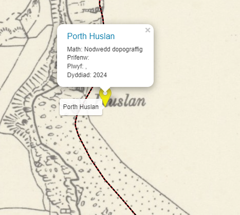
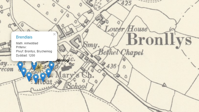
The web map presents digitised scanned images of the original historical maps which have been geographically aligned to the modern map using a process called georeferencing. Each map source has also been 'vectorised'. This means that shapes (polygons) matching the lines drawn on the historical maps have been created digitally, allowing users to click on any landscape feature (field parcel, building, road) to get further information.
The pilot project has now ended, and the results of the research can be seen on the project website. You can discover more about the project by listening to the lecture given by Jon Dollery and Scott Lloyd from the Royal Commission here.
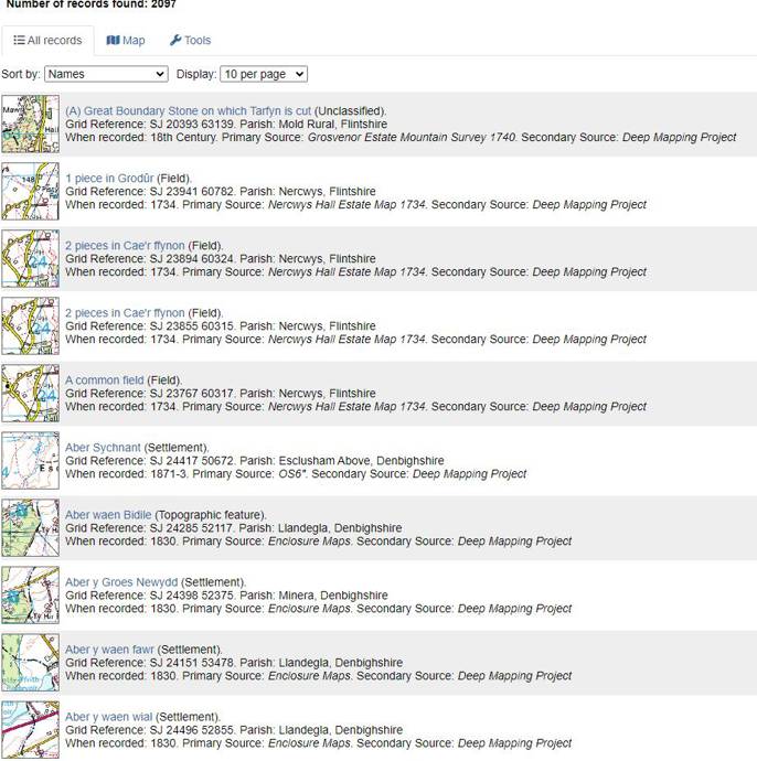
All the maps contain place names, all of which, some 2,000 odd, have now been added to the List. This means that we now have a very decent understanding of the development of the place names in the project area, since we now have lots of names from the Parochialia, the Tithe, and various early maps from this area of the North-East. You can find all of the names collected by the project here.